This means changing some parts of the Proposed District Plan to enable increased housing density and choices in our city.
We have prepared Variation 1 and Plan Change 19 to meet Council’s obligations to enable housing intensification under the Resource Management (Enabling Housing Supply and Other Matters) Amendment Act.
We are also proposing to rezone land in the Northern Growth Area near Pukerua Bay for urban development.
Council publicly notified Variation 1 and Plan Change 19 on 11 August 2022.
View Variation 1 and Plan Change 19 and make a submission. Submissions must be received by 5pm Monday 12 September 2022.
Through recent changes to the Resource Management Act and the National Policy Statement for Urban Development, the Government has directed councils to change their district and regional plans to enable increased housing supply and housing intensification in major urban areas.
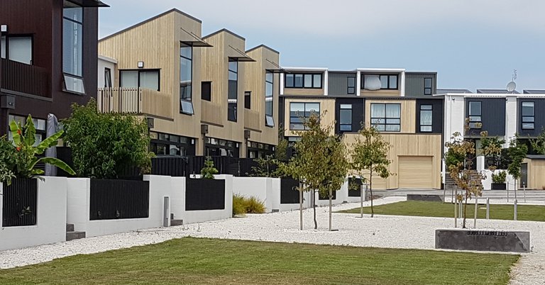
This means the Proposed District Plan and Operative District Plan must change to enable medium-density housing in all residential areas in Porirua. This includes adopting new Medium Density Residential Standards which allow up to three houses of three storeys each (12 metres high) to be built on all residential properties as a permitted activity.
In addition, we are required to identify urban areas where even taller buildings can be built such as within the city centre, local centres and commercial areas, and within walking distance of the city centre, public transport stops and local centres.
To make this happen, Council has notified Variation 1 to the Proposed District Plan and Plan Change 19 to the Operative District Plan.
See Housing Intensification Variation for more information.
We are proposing to re-zone a large rural area near Pukerua Bay to enable approximately 1000 new homes as part of Variation 1. This area is within the Northern Growth Area Future Urban Zone in the Proposed District Plan.
These new homes are needed to provide more housing opportunities for our growing City.
See Northern Growth Area for more information.
In 2020 the Proposed District Plan introduced 1 in 100 year flood hazard mapping for the majority of Porirua’s suburbs, as well as the Pāuatahanui and Taupō catchments as a Natural Hazard Overlay.
Wellington Water Ltd has recently completed hydraulic modelling for the remainder of Porirua’s urban environment catchments including Camborne, Mana, Paremata, Papakowhai, Aotea, Pukerua Bay and Whitby.
These additional flood hazard maps are being added to the Proposed District Plan as part of Variation 1 under the Intensification Planning Instrument.
See Key topics and supporting information for more information.
